


- Managing body+
- Managing body
- Organization chart
- Executive committee
- Parks' Community
- Partnership
- Projects+
- CETS-Carta Europea per il Turismo Sostenibile+
- Forum di presentazione
- Tavolo di lavoro 1
- Tavolo di lavoro 2
- Tavolo di lavoro 3
- Tavolo di lavoro 4
- Progetto Life EREMITA
- Progetto Interreg CEETO-Central Europe Eco-Tourism
- Documents+
- Documenti amministrativi+
- Contributi
- Convenzioni
- Fondo Verde
- Pagamenti e fattura elettronica
- Pubblicazioni scientifiche e Progetti
- Regolamenti
- Statuto
- Tabellazione perimetrale dei Siti Rete Natura 2000 nel Paesaggio Protetto Collina Reggiana
- Convegni e Seminari+
- Convegno ''Il Fiume: da emergenza a infrastruttura verde per il territorio'' Rubiera (RE) 01/06/19
- Seminario "Appennino, ambiente, acqua e clima che cambia" Pavullo (MO) 28/06/2019
- Tenders and Notices
- Privacy policy
- Online payments
- News+
- Newsletter
- Events' Catalogue+
- Flora and Fauna
- Webcam
- Flora and Fauna
- Webcam
- Territory
- Flora and Fauna
- Books, DVDs, and Gadgets
- Territory
- Flora and Fauna
- Books, DVDs, and Gadgets
- Territory
- Flora and Fauna
- Books, DVDs, and Gadgets
- Flora and Fauna
- Territory
- Flora and Fauna
- Books, DVDs, and Gadgets
- Flora and Fauna
- Environmental education
- Books, DVDs, and Gadgets
- Natura 2000 Network
- Activities+
- Activities
- Skiing
- Birdwatching
- Cycle tourism
- Horse riding
- Hiking
- Orienteering
- Archery
- Environmental education+
- Environmental education
- Proposte in Evidenza+
- Il paesaggio bene comune (cod. 8.1)
- Mondo insetti (cod. 8.2)
- Progetti Speciali+
- Il Sentiero dell'Atmosfera (cod. 9.1)
- L'Acqua e il territorio (cod. 9.2)
- Un territorio disegnato dall'Acqua (cod. 9.3)
- Storie di uomini in guerra sulla Linea Gotica (cod. 9.4)
- Soggiorni Verdi+
- Viandanti e pellegrini (cod. 10.1)
- Impronte di natura (cod. 10.2)
- Soggiorni itineranti (cod. 10.3)
- For Citizens+
- Iniziative
- Eventi
- Regulated activities
- Partnership
- Operators' list
- Projects/Experiences+
- PON/FSE Competenze di cittadinanza globale
- Paesaggio Bene Comune
Home » Protected Areas » Parco del Frignano » Books, DVDs, and Gadgets
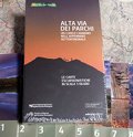
Alta Via dei Parchi - The 8 hiking maps box set, scale 1:50000
Waterproof and tear resistant map
The Alta Via dei Parchi starts in Berceto, near the Cisa Pass in the Province of Parma, and it reaches the Verna cliff first, which overlooks the Casentino valley, and then the hermitage on Mount Carpegna, crossing two national parks, five regional parks and one interregional park: a 500-km-long itinerary reaching 27 accommodation points along the Apennines through Emilia-Romagna, Tuscany and The Marches. To complete the guides the 1:50,000 scale hiking maps covering the whole itinerary and the area of the involved Parks have been realized. In order to produce these maps the cartographic Archive of the Emilia-Romagna Region created a new specific and up-to-date cartographic basis. They are all printed on waterproof, tear resistant and 100% completely recyclable Polyart paper.
The Alta Via dei Parchi starts in Berceto, near the Cisa Pass in the Province of Parma, and it reaches the Verna cliff first, which overlooks the Casentino valley, and then the hermitage on Mount Carpegna, crossing two national parks, five regional parks and one interregional park: a 500-km-long itinerary reaching 27 accommodation points along the Apennines through Emilia-Romagna, Tuscany and The Marches. To complete the guides the 1:50,000 scale hiking maps covering the whole itinerary and the area of the involved Parks have been realized. In order to produce these maps the cartographic Archive of the Emilia-Romagna Region created a new specific and up-to-date cartographic basis. They are all printed on waterproof, tear resistant and 100% completely recyclable Polyart paper.
- Publisher: Ediciclo
- ISBN: 9788865490686
- Scale: 1:50000
- Price: 28.00 €
Item temporarily sold out at Emporio dei Parchi
2024 © Parchi Emilia Centrale - Tutti i diritti riservati
ENTE DI GESTIONE PER I PARCHI E LA BIODIVERSITÀ EMILIA CENTRALE
Sede legale: Viale Martiri della Libertà 34 – 41121 Modena
C.F. 94164020367 • Part. IVA 03435780360
tel 059 209311 • cell 348 5219711 • fax 059 209803
info@parchiemiliacentrale.it • protocollo@pec.parchiemiliacentrale.it
C.F. 94164020367 • Part. IVA 03435780360
tel 059 209311 • cell 348 5219711 • fax 059 209803
info@parchiemiliacentrale.it • protocollo@pec.parchiemiliacentrale.it